Monday, January 12, 2009

A Route for a Pilot Greenway?

Is there an optimal route we should pick for a pilot greenway? The most common suggestions that have come from ABetterShreveport meetings have centered on Bayou Pierre. Some have suggested we choose two sections in particular, one going behind Cenenary's athletic fields (shown below)


and another going between Oakley and 70th (show below)


These are stretches where, conceivably, and with neighbors permission, we could mow the simplest of trails, promote them informally, then demonstrate their use.

This is one of the topics on the agenda at the next ABetterShreveport meeting. (Tuesday morning at 8:15 in room 206 of Centenary Square, for all who are interested.)

Monday, March 31, 2008

A wide simple sidewalk type of path in Belgium

From a Belgium trip blog:

"Cycling is Very Popular in This Part of the World."


"My friend took me cycling along the canal and it was such a pleasurable experience on a bluesky sunny day! Here in Belgium there is something of a culture to cycle, so these lovely big tracks wide and smooth, are common along the canals."

Then, one of the blog's visitors, JudyinPA, then says: "I like those kinds of bike paths. Would enjoy this kind of a trip. Lucky you!" (Tue Oct 7, 2003 15:15 UTC)

Wednesday, March 12, 2008

Mapping the Bayous

Here's a map of bayous, blue is concreted, red is 'natural', and yellow is where bike lanes might be added to certain streets that lightly used.

Sunday, February 10, 2008

From bayous to artificial whitewater parks?


It's been done elsewhere, even in flat places like our own. The above photos were taken in South Bend, Indiana. Their facility is used for world-class competitions and training. Maybe this would provide the incentive we may need to construct what we already need to help solve our low water pressure problems in the city.

The picture below is an artificial course at the United States National Whitewater Center.

Sure does look like some of our bayous, minus the current and rocks. You'd think we'd have access to enough water from the Red River to do this, and while pressure could be issue for our plumbing, other places have used damns, or "weirs," to create the current.

Wikipedia has some info on the different kinds of courses and channels that have been constructed.

Below is a list of artificial whitewater courses for canoe, kayak, and raft around the country, either existing. (source: www.trailsrus.com/whitewater/otherparks.html)

ARTIFICIAL CHANNEL - EXISTING

East Race - St. Joseph River

South Bend

IN

Dickerson Whitewater Course

Dickerson

MD

Lock 32 Erie Canal

Pittsford

NY

ARTIFICIAL CHANNEL - PLANNED

Adventure Sports Center International

Wisp-McHenry

MD

Mississippi River

Minneapolis

MN

Catawba River - U.S. National Whitewater Center

Charlotte

NC

ARTIFICIAL CHANNEL - PROPOSED

Arkansas Whitewater Park

Fayetteville

AR

Susquehanna River

Havre de Grace

MD

Columbia Canal

Columbia

SC

POSSIBLE PROJECTS - UNCONFIRMED

Feather River

Oroville

CA

Inglis

FL

Cedar River (Shell Rock, Waverly, Cedar Falls and Waterloo)

Peoria

IL

StreamTeach, Inc.

St. Louis

MO

Williamsport

PA

Park City

UT

Word is that our own "Bayou Chapter" of the Ozark Society has proposed constructing something like this for us. You go, paddlers!

Monday, January 28, 2008

There are a few Shreveporters have long thought our bayous could be used as opportunities to significantly improve our city's quality of life. One idea is a type of "linear park," such as the "String of Peals" plan developed some years ago. From what some have told me (Kim Mitchell, Murray Lloyd, Tim Wachtel, I believe?) it included a plan that would link some of our city's parks through paths alongside certain bayous.

Other visions have included recreating the slow moving streams and marsh areas we originally had, assuming previous flooding problems could be eliminated.

The least expensive modification would that the parks are left as is, but made more accessible to the public, and maintained in ways to minimize stagnant water buildup.

Another idea for certain bayous in particular would be to build features and perhaps control quality and flow of water to create a world-class white water course for canoeists and kayakers.

Who knows what the best option for us is? Maybe it's combination of various things in different places. The possibilities are likely more than any of us can imagine.

Sunday, January 27, 2008

Shreveport Map of Bayous to Use

Here is a map of possible bayous to use as pedestrian and bike paths. It includes a few underused streets, as well, parts of which could used as separated bike lanes.

We suggest these routes because:
  1. they use existing infrastructure that is underused
  2. they are accessible to the most people
  3. they provide routes of alternative transportation to current popular destinations
  4. they provide routes to a revitalizing downtown (Active downtowns are important for fulfilling community life, sociologists would point out, because of the opportunities for social interaction they provide. Town centers are the among the only settings where public spaces are located between places of retail, work, and residence. This lets people happily "bump into each other" as they shop, work, recreate, etc.)
And, here's a map with pictures.

Wednesday, January 23, 2008

Bayou Pierre, Before and After?

Apparently these bayous once helped build Shreveport. Barges would unload supplies at Oakley, Gilbert, and Fern, and the turn around was where it now crosses under Alexander.


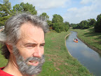
More recently, Bayou Pierre was used for boating, fishing and swimming, and without health consequences not so long ago. I recently met a beautiful, fit, 70 year old women who swam as a child in the very place pictured here!

Our bayous are public spaces that run throughout our neighborhoods. But the engineers who devoted them exclusively to drainage, decades ago, probably weren't aware of the importance of greenspace within cities to the health and happiness of their residents.

But it's a well-established fact by researchers that a city's amount of park space is directly related to it's citizens' quality of life, not to mention the amount of money produced by it's economy because it's citizens want to invest in it.

Many cities are in the same position as ours, with few sidewalks and parks, let alone the hot new innovation of "greenways" that effectively combines the two. But very few cities have the opportunity to create a network of beautiful, tree-lined, linear parks.

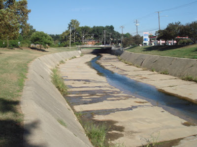
Some before and after shots for the sake of our imaginations:


And, who's to say we shouldn't find a way to enjoy the water?

or that we should age much in the process?

Concrete Capped Bayou at Columbia Park

This is a part of the bayou that runs through Columbia Park (between Creswell and Line Ave. just north of Kings Highway).
Certain techniques have been used effectively to address crime and vandalism concerns. For example, experience has shown that posted warnings and surveillance cameras can make areas relatively safe. In the case of walk-bike paths, they might them even safer than they were before the paths increased the foot traffic.

"He ain't smelly. He's my bayou."

(Yeah, that's right. And if you know the Osmonds version of that song, you're just as much a sucker for good cheese as I am. Sing it Merril!)
Seriously though, right now, this beautiful scene isn't really accessible to Shreveporters, unless you dare to hop a fence. Because these bayous are fenced and most of us don't have contact with them, and because their use is drainage, which sounds unseemly, many think they are smelly and full of vermits. But I've taken jogs on various routes through them, and usually enjoy fresher air there than in the street. And the only animals I've seen have been alive, and they've been egrets, some herons, a couple of cats.